Destination: Moiciu De Sus
Starting Location: Bucegi Mountains High Valley
Today’s Kilometers: 19.00
Trip Kilometers: 414.75
1300 GPS: 045 25 13.4N 025 24 39.4E
And that is: A shoulder of the Bucegi Ridge
ALT: 22205m
Dayend GPS: 045 25 30.0N 025 21 40.7E
Altitude: 1133
And that is: A nice man’s house, Moiciu de Sus
Distance advanced: About 3 km car lift, at least 16 km by foot, maybe more counting poking around in the fog.
Weather: Bell-clear morning, but things went to pot by 1230. Heavy fog, drizzle, and rain for the rest of the day. I spent perhaps 2-3 hours total in a proper rainstorm.
The plan was simple: Since I was in this lovely little, if remote valley and needed to advance West, climb the seemingly small ridge at the end of the valley, turn west, and walk a ridge until a town appears in the valley, and then down off the ridge to the town. If time permits spend the end of the day road-marching, get some kilometers in.
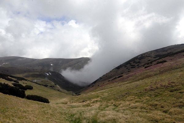
Cue the Jaws theme music, Bucegi Mts. Looking back downhill. That cloud was following me up the rise, and caught up to me pretty much the same time I got on top. Thursday, June 17, 2010
I slept poorly the night before due to partying Romanians and a really overdone lightning and thunderstorm lasting all night. It was like German opera, it went on and on and just got louder and more emotional. So I woke up at 0730 and what with feeling a bit stiff and not planning a big day, I wasn’t out the door until 0900.
Things started off great, the moment I started strapping up a deer walked out of the forest onto the main road, perhaps 200 meters off, broad daylight, and the deer for reasons best known to it was abandoning cover to head towards a pasture used by horses, and a little further up some humans had set up tents. This was a pretty ditzy deer too, she wandered across the road, sort of climbed up on a little mound and inspected all this non-deer-safe activity, and sort of stood there.
I was able to get the long lens on the camera, but due to an intervening fence didn’t get any worthwhile shots.
The next thing that happened was, a Mitsubishi 4WD pulls up and inside nice couple with a husband named Laurentu Costescu. I may have the first name a bit misspelled, but it’s Romanian for “Lawrence”, which as some of you know is the middle name of one of my brothers. Good omen.
Things improved when they pointed out they were heading roughly in my direction, how about a lift?
I was agreeable and that shaved maybe 3 km of morning road walking, which put me in a good mood.
After chatting with a hotel worker we figured out which path out the valley I should take, and I set off. Since there was a Salvamonte (Romanian Mountain Emergency Services; these are the tough mountaineers that come get you when you the tourist get in trouble someplace high up in the Carpathians) building right on the way I chatted with the staff, well as much as my understanding of Romanian would allow, and with their help was absolutely sure I was on the right track.
It was a beautiful, mountain summer morning, with birds chirping and butterflies doing aerobatics, and as I climbed I entered a postcard perfect high valley. Overhued green grass, dramatic rocky outcrops framing the valley, a babbling stream down the middle, and dairy cows so mellow they generally didn’t bother getting up as I walked by them. The track was good but I was slowed down just a tad because I had the camera out so much.
So the path went up and up, out of pasture and into scrub evergreen, and still on the right is this white bubbly stream, sometimes jumping over a waterfall. I was moving well and I got to what I thought was the ridge by 1130.
It wasn’t, the real ridge was above the evergeeen, more sheep pasture, some of it with entire hills violet with wildflowers, and a good ways higher. But the path was grass and I wasn’t hurrying, and up I went.
Then the weather started to tank, first clouds, then drizzle, and when I finally got to the top of the ridge, pea-soup thick fog. This was not good, I needed to make an important turn on top of the ridge, and at times I couldn’t see from one trail marker to the next, but between following the ridge path and dead reckoning I was able to figure out how the ridge path ran. Question was, which was the right route for me?
Then it started raining, hard, and there was absolutely no cover, it was like getting caught in a monsoon on a football pitch. I threw on my Polish gortex rain jacket, threw the poncho over my head and as much of the backpack I could manage, and sat down to wait the weather out. I ate lunch (and a pretty measly one at that, bread and meat spread, bad supply planning there) sitting under the poncho. I also consulted Mr. GPS and the paper map, and they seemed to agree I needed to head off, well, westwards.
The rain abated a bit and I packed up, trying to take advantage of extended LOS – I could see two or three trail markers ahead, but I had no idea what the next hill looked like or whether the scenery was pretty or dull. All I could see was fog. But I was pretty proud of myself, I had gone to ground in a mountain gullywasher on an open ridge, and I was just a tad damp. Mostly I was dry – so I was patting myself on the back for that.
I admit I wasn’t always sure, and my paper map is now sodden and fallen apart from repeated checks, but I wound up on the correct route, which took me along a ridge line some 5 – 6 km.
The views, what I could see between the fog and the rain, were breathtaking, big jagged mountains, dramatic limestone cliffs, and here and there flocks of sheep. You could see things 4 kilometers away, heck, at that distance it’s still possible to hear the shepherds shouting and the dogs barking. But like I said, this was momentary glimpses between precipitation which, eventually, had my water-resistant boots completely soaked. The Ppolish gortex jacket however stood the test of fire, it basically kept me mildly damp and quite warm.
Eventually I crossed the ridge my instincts had been telling me for a couple of hours I needed to cross, because I was pretty sure the valley I needed was on the other side. This led pretty quickly to a big 4-way trail intersection, and good thing it was big because the fog was back again and LOS was down to a couple of hundred meters. More map checking just to be sure, and now it was downhill.
It was only now that I was irritated at the fog, because the trail led me into some cool boulder fields, and just barely, on my right I could see these giant ragged cliffs that had dumped the stones, they must have gone up 400-500 meters, just jaw-dropping terrain. But pix weren’t possible, too much fog. Bothersome.
If any one reading this is interested in a long 1-2 day hike in the Bucegi region, then I kept notes and just write me and I’ll give you the details. In a full day of good weather it would be a glorious walk.
Meanwhile, I had to get off the mountain and out of the rain. A steep trail, pretty much right where the map said it should be, led (finally) down into the valley, first through a pasture and then a fir forest. Dutifully, I took the wide-angle off and slapped the telephoto on the camera; this was a little-frequented fir forest in the back reaches of Bucegi National Park: I had been told specifically bears hang out there.
No bears encountered, but a huge swarm of flies showed up the moment I entered the woods, but they didn’t accompany me downhill.
It was a muddy work going downhill but it ended, and I found myself walking on your standard forestry trail. Again it started pouring, but by this point I didn’t care much about being wet, I was just getting tired of walking.
Once Mr. GPS told me I was about an hour out of the first village, I poured on the coal and 45 minutes later I was in Moiciu De Sus. Since it was (still) raining there weren’t that many locals outside, but the second one I asked about a place to stay said, essentially “why not here?”
I’m still not clear if he expects me to pay, the owner seems to have had a social engagement and has left me in his house. But the radiators are burbling and my soggy togs (sorry about the word choice) are drying as I write this. Once I get some food in my belly, things will be just fine.
Tomorrow I have an easy 15 km. Road hike to Bran, where I am scheduled for 3 days of journalist work, and not walking unless I get fed at the end of it.
"Boola Boola!"
Stefan Korshak is a reporter and blogger at Trail Journals. You can read his blog entries at http://www.trailjournals.com/entry.cfm?id=311030